The Liberal Democrats have been hoping to use location based tech to target floating voters.
In the United Kingdom, the Liberal Democrat party has chosen to go the high tech route by employing geolocation technology in order to be able to gear the content on the party’s official website specifically toward the local issues of the individual who is viewing it.
This is all being implemented ahead of the next general election in the hopes of appealing to a target group of voters.
This makes the Liberal Democrats the first among all of the parties to take advantage of the hyper local potential of geolocation. They have worked with Digital Element in order to put this technology into place. The tool that was created for them is able to determine an individual’s location at a sub-regional level so that they will automatically view the campaign literature of the candidate who is closest to them.
Through the use of geolocation technology, voters will see information about the issues most relevant to them.
 That said, despite the fact that users will automatically be presented with local material, this doesn’t mean that they won’t be able to access the national messages that have traditionally been posted on the party website. That will still be available to them, but upon initially accessing the site, they will first see the local content, issues, and candidate information displayed.
For example, someone in southeast London will initially see information about the candidate named Simon Hughes, for Old Southwark and Bermondsey, but that individual would also be able to check out the broader national information, as well. This could potentially have greater appeal and relevance to that person.
According to the head of digital communications for the Liberal Democratic party, Bess Mayhew, when speaking about the implementation of the geolocation technology, “Viewing web content that is more personal and less generic can really impact the way people vote, and small margins can make a huge difference to the final result. In this election in particular, we’re going to see a lot more marginal seats, so those few extra votes can really make the difference.”
This application provides a heat map to show an area’s “happiness” level and make marijuana legal in more countries.
A man named Paulo Costa, from Brazil, has been using cannabis to help to control the seizures that are associated with his epilepsy, and is now using a geolocation based mobile app to help to spread “happiness” and encourage the decriminalization of cannabis use, particularly for medical purposes, in more countries around the world.
The increasingly popular mobile app has been nicknamed “Foursquare for Stoners” in Brazil.
That said, as playful as the tone of the tongue in cheek geolocation app may seem, and as much as it has been designed to be fun to use, it also has a more serious purpose, underneath. Costa has been using cannabis to help to control his seizures since he was first diagnosed with epilepsy at the age of 18 years. A growing body of reputable evidence has been suggesting that the promising results that Costa has been experiencing are not isolated to himself. Studies are showing that controlled use of medicinal marijuana can help to improve the quality of life of epilepsy patients.
The idea for using geolocation in a mobile app came to Costa when he was hanging out with his friends in Brazil.
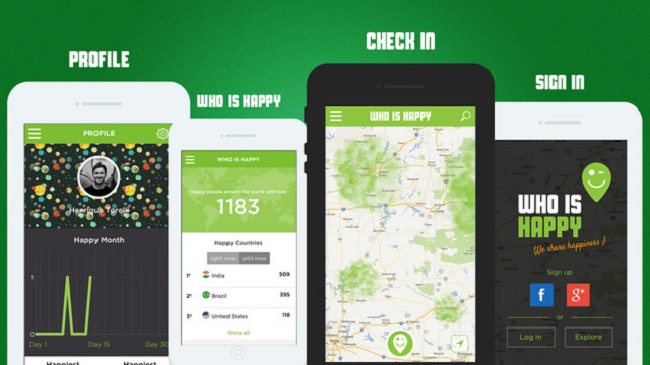
 Together, they came up with the “Who is Happy” mobile app, which uses location based technology to create a heat map of cannabis users around the world that allows them to create a real time broadcast of their “happiness”.
To use the mobile app, the idea is to simply tap the green “happiness” icon on the smartphone screen whenever cannabis is being used. This adds a haze of green smoke to a 1 kilometer radius around the current location of the individual on the map. This suggests that an application user is “happy” in that region of the world. By zooming out on the map, it becomes possible to see other local and more distant regions of the world where there are others who are “happy”. This allows for the collection of happiness stats.
Of course, it is not just happiness that is being recorded through this geolocation app. The idea is to help to add to a broader effort to decriminalize the use of marijuana in countries around the world. It has already found itself among the top 30 app downloads in Brazil and is rapidly increasing in popularity worldwide.
 That said, despite the fact that users will automatically be presented with local material, this doesn’t mean that they won’t be able to access the national messages that have traditionally been posted on the party website. That will still be available to them, but upon initially accessing the site, they will first see the local content, issues, and candidate information displayed.
 Together, they came up with the “Who is Happy”